Content
- storm ? cyclone ? tornado ? hurricane ? typhoon ?
Hurricanes, cyclones, and typhoons are all the same weather phenomenon; we just use different names for these storms in different places. In the Atlantic and Northeast Pacific, the term “hurricane” is used. The same type of disturbance in the Northwest Pacific is called a “typhoon” and “cyclones” occur in the South Pacific and Indian Ocean.
- anatomy of a cyclone
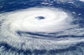
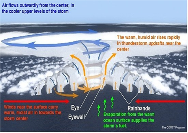
Eye: The eye is the "hole" at the centre of the storm. Winds are light in this area. Skies are partly cloudy, and sometimes even clear.
Eye wall: The eye wall is a ring of thunderstorms. These storms swirl around the eye. The wall is where winds are strongest and rain is heaviest.
Rain bands: Bands of clouds and rain go far out from a hurricane's eye wall. These bands stretch for hundreds of miles. They contain thunderstorms and sometimes tornadoes.
- the forecast track ? How to read ? Who made it ? How ?
Anthropogenic warming by the end of the 21st century will likely cause tropical cyclones globally to be more intense on average (by 2 to 11% according to model projections for an IPCC A1B scenario).
Anthropogenic warming by the end of the 21st century will likely cause tropical cyclones to have substantially higher rainfall rates than present-day ones, with a model-projected increase of about 10-15% for rainfall rates averaged within about 100 km of the storm center.
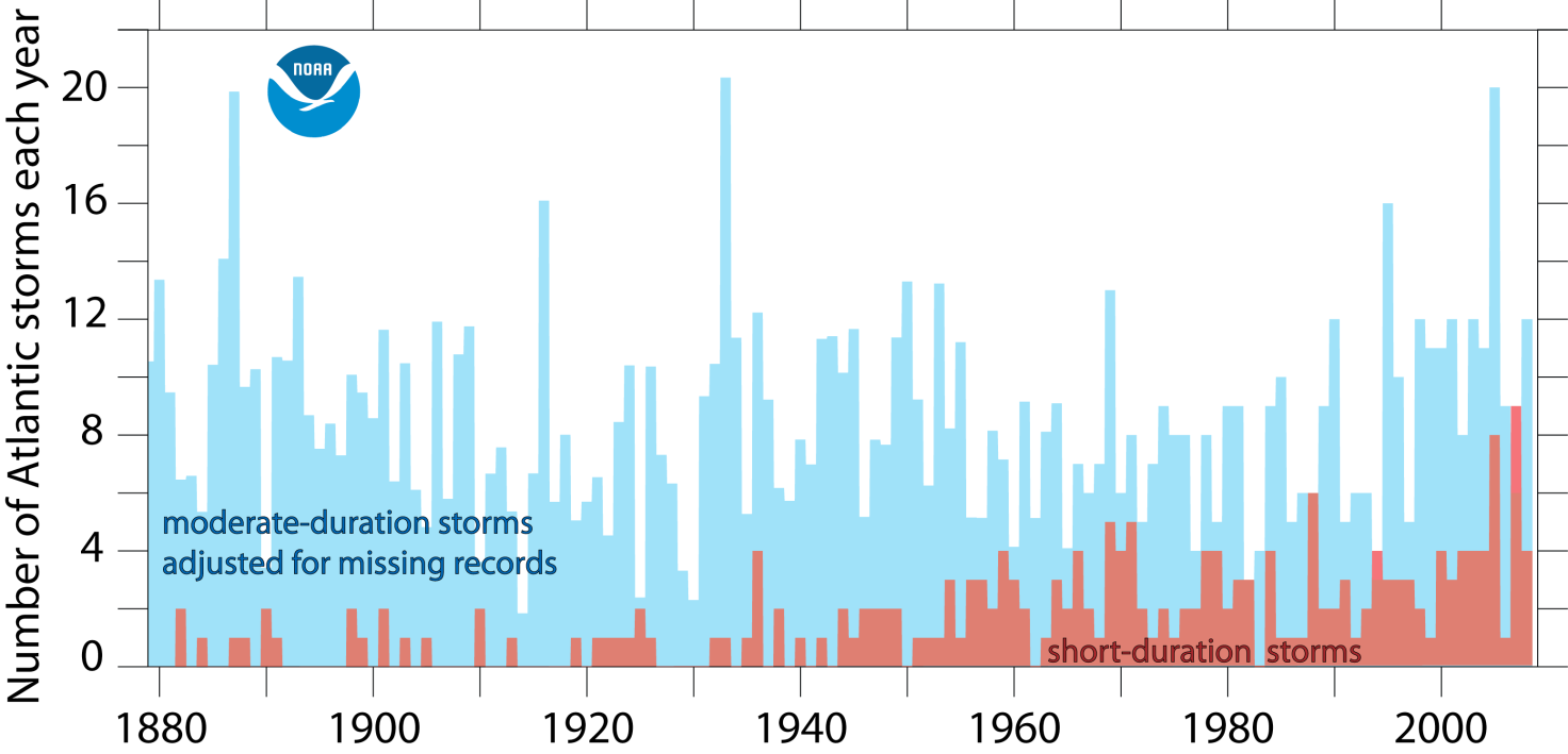
Observed records of Atlantic hurricane activity show some correlation, on multi-year time-scales, between local tropical Atlantic sea surface temperatures (SSTs) and the Power Dissipation Index (PDI) on this EPA Climate Indicators site. PDI is an aggregate measure of Atlantic hurricane activity, combining frequency, intensity, and duration of hurricanes in a single index. Both Atlantic SSTs and PDI have risen sharply since the 1970s, and there is some evidence that PDI levels in recent years are higher than in the previous active Atlantic hurricane era in the 1950s and 60s.
- Where does it form ? why ? (tropical, temperature, evaporation ...)
Although tropical cyclones can occur in many parts of the world, about 75% of all tropical cyclones form in the Northern Hemisphere. The western North Pacific Ocean has the greatest number of storms per year. There are also areas that are not affected by tropical cyclones, such as the South Atlantic where the ocean is too cool.
Hurricanes are absent near the equator because of the lack of Coriolis force. Where this force is absent the air moves toward the centre of a low-pressure area to fix the initial imbalance. The majority of hurricanes move following the dominant streams between the latitudes of 8° and 15°,where Coriolis force can cause a wind rotation around the low-pressure area. Tropical cyclones of the North-Atlantic area dissolve when they hit Mexico or Texas, while the cyclones that go to the North and Northeast have more odds to stay alive and consume gradually between USA and Bermuda. In the Indian Ocean hurricanes insert themselves in Monsoon’s streams so they mainly go to the North or South instead of West or East.
- What causes a cyclone to form ?
Hurricanes are intense low pressure areas that form over warm ocean waters in the summer and early fall. Their source of energy is water vapour which is evaporated from the ocean surface.
Water vapour is the "fuel" for the hurricanes because it releases the "latent heat of condensation" when it condenses to form clouds and rain, warming the surrounding air. (This heat energy was absorbed by the water vapour when it was evaporated from the warm ocean surface, cooling the ocean in the process.)
Usually, the heat released in this way in tropical thunderstorms is carried away by wind shear, which blows the top off the thunderstorms. But when there is little wind shear, this heat can build up, causing low pressure to form. The low pressure causes wind to begin to spiral inward toward the centre of the low. These winds help to evaporate even more water vapour from the ocean, spiralling inward toward the centre, feeding more showers and thunderstorms, and warming the upper atmosphere still more. The showers and thunderstorms where all of this energy is released are usually organized into bands (sometimes called "rain bands" or "feeder bands"), as well as into an "eye wall" encircling the centre of the storm. The eye wall is where the strongest winds occur, which encircle the warmest air, in the eye of the hurricane. This warmth in the eye is
produced by sinking air, which sinks in response to rising air in the thunderstorms. The winds diminish rapidly moving from the eye wall to the inside of the relatively cloud-free eye, where calm winds can exist.
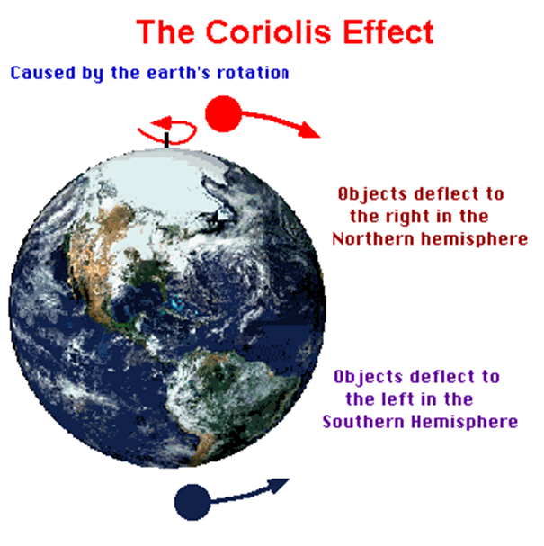
- What is the Coriolis effect ?
The Coriolis Effect is an apparent force that makes things (like planes or currents of air) traveling long distances around the Earth appear to move at a curve as opposed to a straight line.
The Coriolis effect also works on the circulation of atmospheric air. Winds are air mass which moves from areas of high pressure to areas of low pressure. If the Earth didn’t rotate (and if friction didn’t exist), the winds would move in a straight line. The Earth’s rotation and the Coriolis effects mean that the winds are deviated to the right in northern hemisphere and to the left in the Southern. This deviation depends on the velocity of the wind; it is higher towards the poles and weaker towards to equator.
The Coriolis effect is most important in high-altitude winds. In fact, friction has a larger influence at low-altitudes, slowing the winds and reducing the Coriolis force. In the northern hemisphere, air-pressure differences (the so-called pressure gradient) and the Coriolis effect mean that winds move in a clockwise direction around low- pressure centres (cyclonic flow) and in a clockwise direction around high-pressure centres (anticyclonic flow). The situation is the exact opposite in the southern hemisphere.
Coriolis effect is fundamental to the climate of the world, billions of animals and plants and therefore to the life you lead.
- How can we divide hurricanes?
|
Intensity |
Wind Speed |
Damage |
|
Category 1 |
74- 95 mph |
MINIMAL: tree branches, shrubs, unanchored mobile homes |
|
Category 2 |
96-110 mph |
MODERATE: mobile homes, poorly constructed buildings, some trees down |
|
Category 3 |
111-130 mph |
EXTENSIVE: small buildings damaged, large trees down, mobile homes destroyed |
|
Category 4 |
131-155 mph |
EXTREME: outer walls damaged, roof failure on small buildings, extensive damage to doors and windows, mobile homes destroyed |
|
Category 5 |
>155 mph |
CATASTROPHIC: complete roof failure on many buildings, some buildings destroyed, severe window and door damage, mobile homes destroyed |