Natural disasters
| Site: | Spark: piattaforma di e-learning del Liceo Majorana |
| Course: | eHAND: Effects of Human Activities on Natural Disasters |
| Book: | Natural disasters |
| Printed by: | Utente ospite |
| Date: | Monday, 25 May 2026, 9:39 PM |
Description
Natural and disasters
1. Natural and induced disasters in Europe
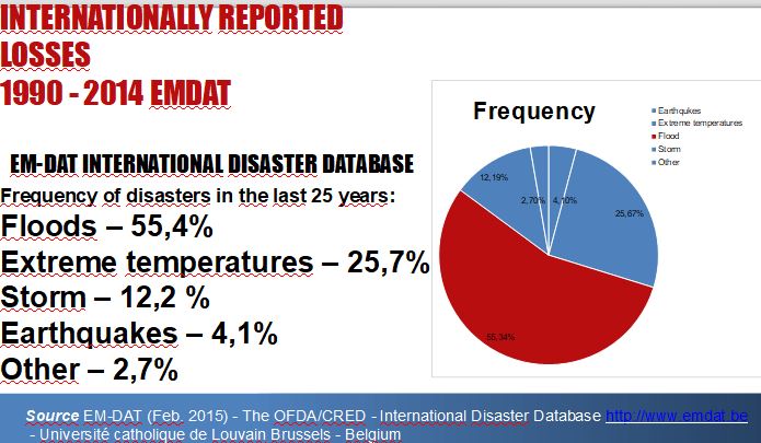
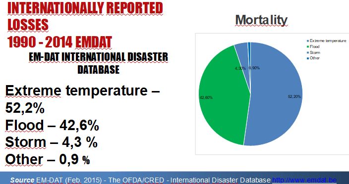
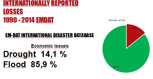
The number and impacts of disasters have increased in Europe in the last decades, according the reports by the European Environment Agency (EEA)
The Agency's reports addresse three different types of hazards: hydrometeorological or weather related (storms, extreme temperature events, forest fires, droughts, floods), geophysical (snow avalanches, landslides, earthquakes, volcanoes) and technological (oil spills, industrial accidents, toxic spills from mining activities).
The increase in losses can be explained to a large extent by higher levels of human activity and accumulation of economic assets in hazard-prone areas, but also, to a smaller extent, by better reporting. Although the share of losses attributable to climate change is currently impossible to determine accurately, it is likely to increase in the future, since the frequency and intensity of extreme weather events are projected to grow.
The most important hazards in our Countries
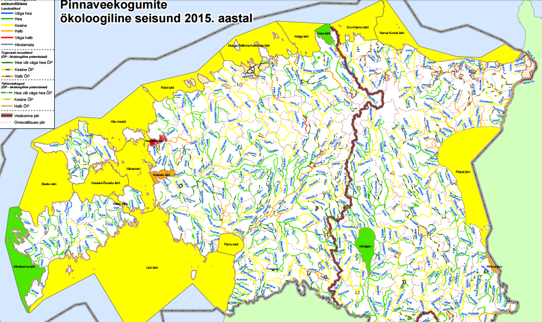
 Estonia
 Greece
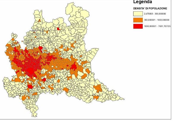
 Italy
Italy
 Portugal
 Reunion
 Romania
 Turkey
2. Estonia
2.1 Shale mining (in the north-east of Estonia)
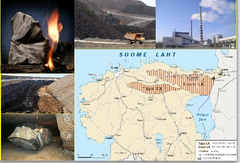 Eesti Energia (Estonian Energy) is a
company responsible for electricity
supply in the country. The company
mines approximately 15 tonnes of shale
per year.
Consequences 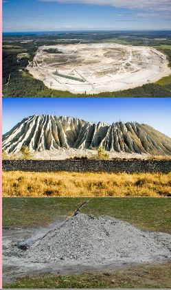
10 000 ha. are covered with quarries and slagheaps;
Mines have made 20 000 ha. of territory unsuitable for living
or any other activity except for shale mining;
Near the power stations there are piles of ash which fills
subterranean waters, forms alkaline compounds. As a
consequence, water reserves and agricultural lands cannot be
used in any way
Getting electricity by means of shale burning
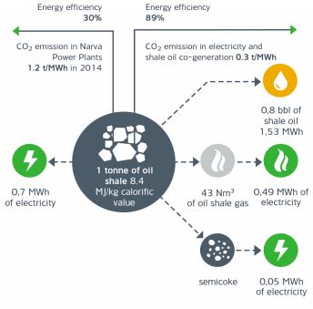
Power Plants running on shale oil produce over
90% of all the electrical and thermal energy, which
is consumed in Estonia.
Besides that shale is one of the cheapest energy
sources, shale burning is one of the dirtiest ways to
produce energy. After oil shale burning there are
5-5,5 million tonnes of burnt shale ashes emitted
per year as well as air polluting substances
2.2 Water pollution
 After the IIWW 3 millions tonnes of
chemical weapons consisting of 14
poisonous radioactive substances were
dropped into the Baltic Sea. Plus, there are
a few sunken nuclear submarines in the
depths of the sea.
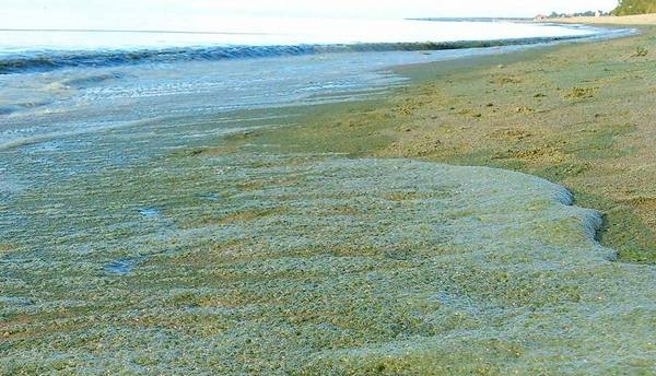 The emergence of cyanobacteria is a
result of hot weather (+35°C). The
substances that cyanobacterias emit may
cause respiratory muscle paralysis, kidney
and liver tissue destruction and death.
2.3 Deforestation

About 54% of Estonia is covered with forests
(2,284,000 ha.)It causes:
Animals and birds leave their habitats
Cutting out valuable species of plants
Lack of oxygen


3. Greece
3.1 Earthquakes
Greece is the most seismic country in Europe
 The high seismic activity of the country is due to the fact that it is located at the boundary of the Africa-Eurasia convergence.
The Anatolian plate rotates counterclockwise.
From the west, the Adriatic microplate rotates counterclockwise
l

The externa Aegean area is subject to a general
compressional stress field and the inner Aegean area
experiences a general extensional stress field.
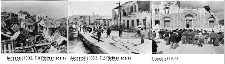
Greece often hosts large magnitude earthquakes, whilst a moderate or small magnitude earthquake is felt every 2-3 days on average
Only a few cases have been recorded as «devastating» for the human environment or loss of life
3.2 Volcanoes
Greece has 39 volcanoes. The active ones are arranged in an arc (Greek Volcanic Arc)
and comprise from West to East the volcanoes of: Soussaki, Methane, Milos, Santorini, Yali, Nisyros and Kos
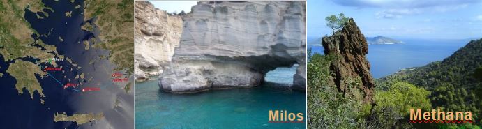

But the most famous volcano in Greece is Santorini
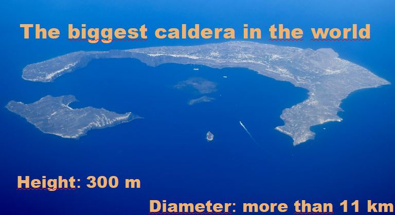
The Minoan eruption happened around 1645 BC and it was one of the largest volcanic events on Earth in recorded history. It devastated the island of Thera (now called Santorini), including the Minoan settlement at Akrotiri and communities and agricultural areas on nearby islands and the coast of Crete with a related earthquake or tsunami
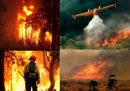
3.3 Fires
Factors that aggravate fires : temperature, humidity, slope, wind.
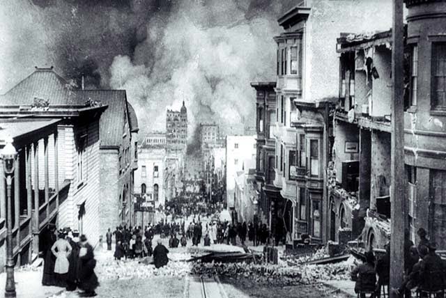 The greatest fire that occurred in Thessaloniki happened in 1917
It destroyed two thirds of the city leaving more than 70,000 homeless. The fire burned for 32 hours and destroyed 9,500 houses within an extent of a square kilometer.
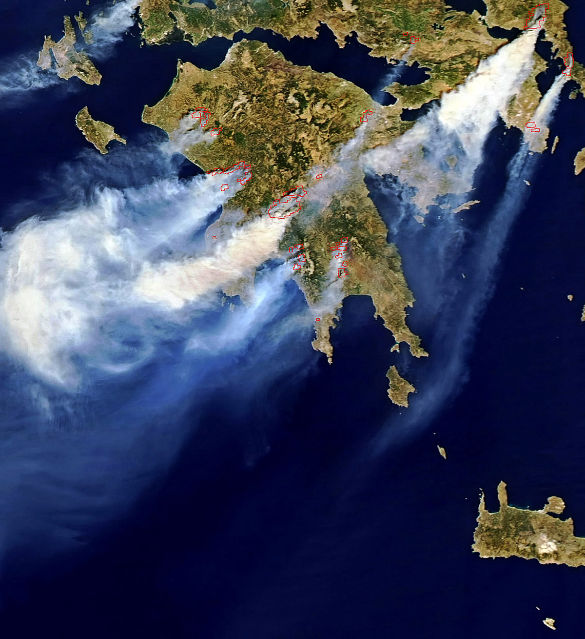 The 2007 Forest Fires
A series of massive forest fires that broke out in several areas across Greece throughout the summer of 2007
The death toll in August alone stood at 67 people
 |
|---|
3.4 Floods
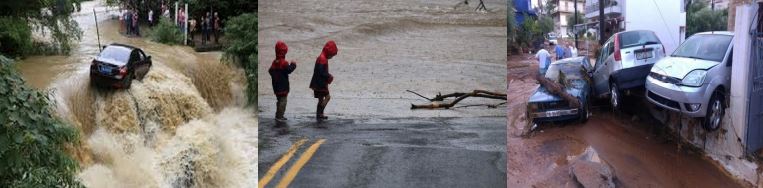
Greece has mainly suffered from flash floods. A flash flood is a rapid flooding of geomorphic low-lying areas: washes, rivers, dry lakes and basins.
It may be caused by heavy rain associated with a severe thunderstorm, hurricane, tropical storm or meltwater from flowing-over ice sheets or snowfields.
Flash floods can occur in unexpected times and are very deadly concerning
Oraiokastro, our school’s region, has been struck by floods on numerous occasions during the last years. The landscape and high altitude of Oreokastro are the reasons why floods are very susceptible to occur, especially during autumn
3.1. Earhquakes mythology
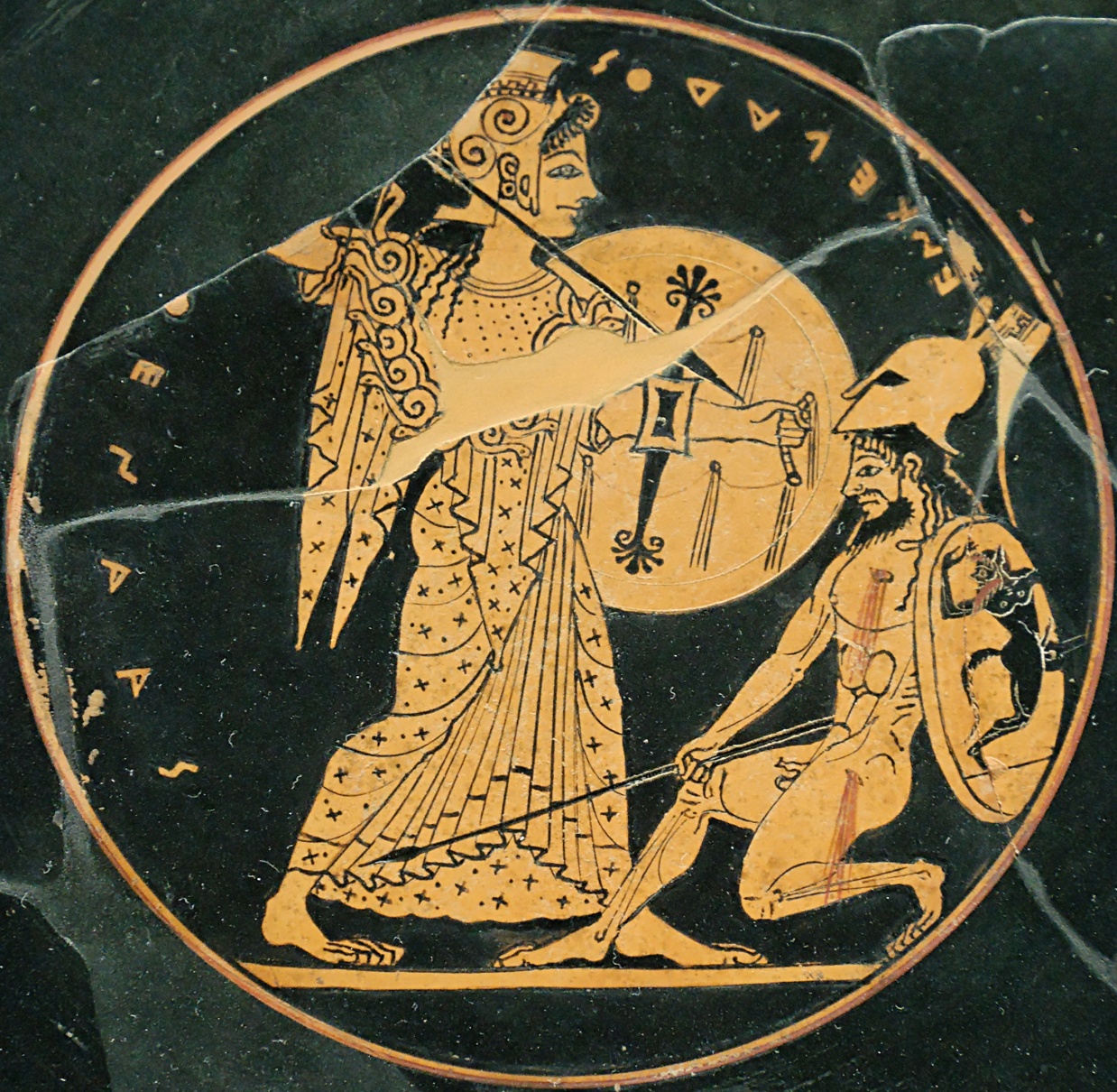 Enceladus, the son of Tartarus and Earth, led the Giants
during Gigantomachy, the Battle between the Gods and
the Giants
Whenever Enceladus tries to move or sigh,
he causes earthquakes or volcanic eruptions
4. Italy
Environmental risk is defined as the probability that a certain natural phenomenon may harm to human lives and/or anthropic activities
According to the recent publication ‘Natural Hazard Risk Atlas 2014’ Italy is the eighth country in the world and first in Europe in terms of risk with regard to natural events
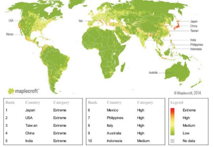
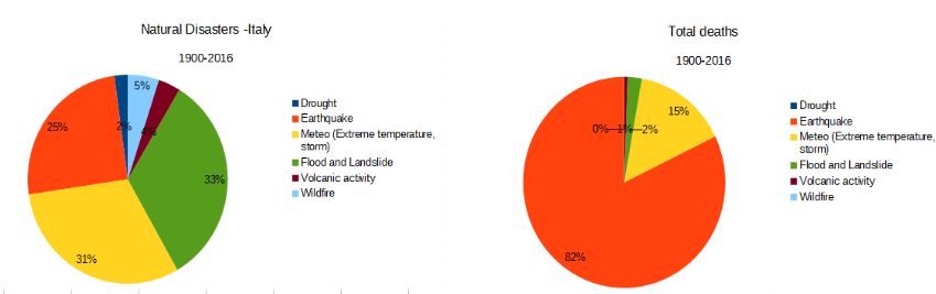
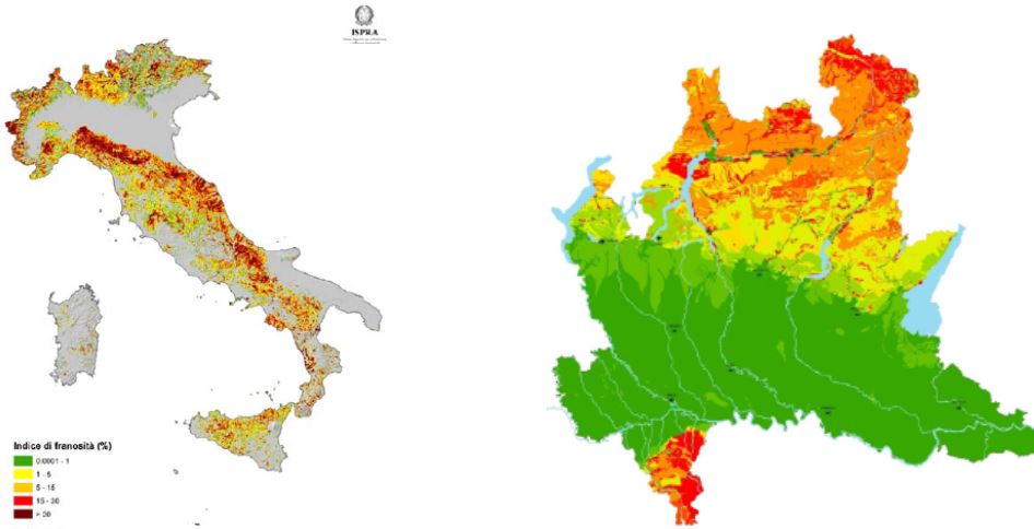
Risk maps for Italy ( data from C.R.E.D. http://www.cred.be )
4.1 Earthquakes

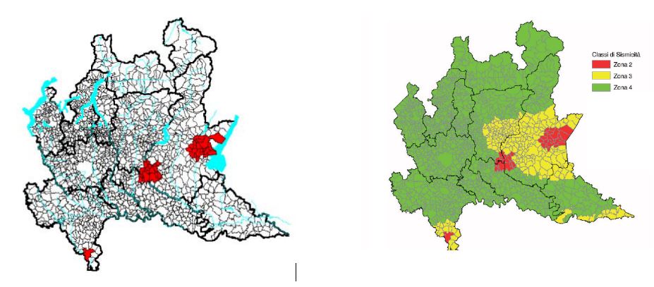
Italy is one of the countries in the Mediterranean area with the highest seismic risk, due to its particular geographic position at the convergence of the African and Eurasian plates. The highest seismicity is concentrated in the central-southern part of the peninsula, along the Apennine ridge (Val di Magra, Mugello, Val Tiberina, Val Nerina, Aquilano, Fucino, Valle del Liri, Beneventano, Irpinia) in Calabria and Sicily and in some northern areas, like Friuli, part of Veneto and western Liguria. Only Sardinia is not particularly affected by seismic events.
In 2,500 years, Italy has been hit by over 30,000 medium to strong earthquakes measuring more than grade IV-V on the Mercalli scale, and by around 560 events of an intensity equal to or higher than grade VIII on the Mercalli scale. In the twentieth century alone, 7 earthquakes had a magnitude of 6.5 or more (grade X and XI on the Mercalli scale
In Italy, the relationship between the damage caused by earthquakes and the energy released during the events is much higher than in other countries with high seismicity, such as California or Japan.
4.2 Eruptions
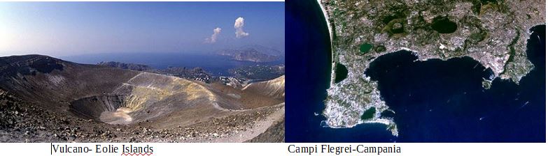
Italy, along with Iceland, has the highest concentration of active volcanoes in Europe and is one of the first countries of the world for number on inhabitants exposed to volcanic risk
In Italy volcanism owes its origin to a wide ranging geological process, involving the entire Mediterranean area and linked with the Euroasiatic and African tectonic plates converging together.
This process, begun 10 million years ago, at the same time as the mountain ranges of the Apennine chain were being built up, is due to the African plate sliding underneath the Euroasiatic one with subsequent formation of areas characterized by volcanism. It is in fact in these areas, inside the earth, where the conditions are created to form magmas and to propel them up towards the surface.
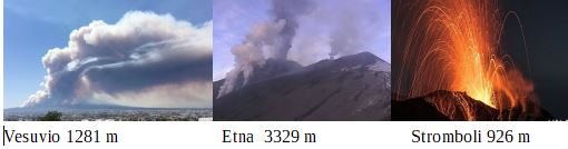
Even though less frequent and devastating than earthquakes, volcanic eruptions are still a great hazard for the densely populated zones in the Italian territory.
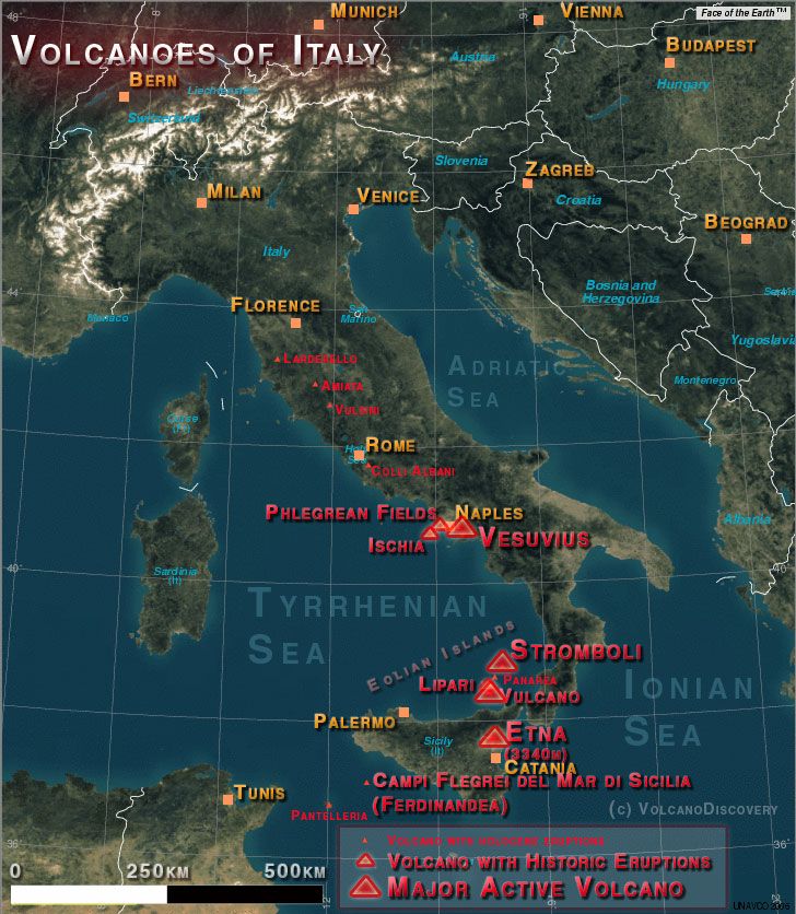 Italy is a volcanically active country, containing the only active volcanoes in mainland Europe
 |
 |
|---|
4.3 Floods and landslides
Italy has a long record of hydro-geological related events. Given its peculiar geomorphological conformation, Italy is particularly prone to floods and landslides. According to the recent 2015 update of the report on hydro-geological risk in Italy by the Higher Institute for Environmental Protection and Research (Istituto superiore per la protezione e la ricerca ambientale, ISPRA), at least the 18% of the national territory is exposed to hydrological or geological risk, affecting 88% of the Italian municipalities.
in Italy between AD 1279 and 2002 more than 50,593 people died, went missing, or were injured in 2580 flood and landslide events. The number of evacuated and homeless people for the same period exceeded 733,000.Harmful events were inventoried in 26.3% of the 8103 Italian municipalities. Fatal events were most frequent in the Alpine regions of northern Italy and were caused by both floods and landslides.
Landslide risk
Flood risk
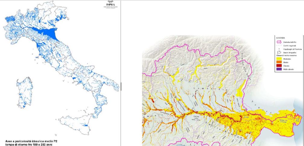
Harmful landslides are triggered by highintensity or prolonged rainfall, rapid snowmelt, seismic shaking, and volcanic activity. Human activities including construction, excavations, mining, intense ploughing, and deforestation, contribute to the triggering/ of harmful landslides. The three most catastrophic landslides and floods events in the 20th century were all caused by or were associated with the presence (Vajont) or the failure (Gleno) of a dam or a man-made embankment (Stava). These catastrophic events indicate the potentially destructive effect of artificial structures and that poor planning in the design and management of man-made structures can result in numerous casualties. The failure of a landslide dam is also potentially a very destructive event, something that has also occurred in Italy (Vogogna)
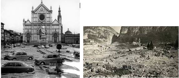
Florence Vajont
4.4 Biodiversity loss
Italy is among the European countries richest in biodiversity, due mainly to a favourable geographical position and a wide variety of geological, climatic and vegetation conditions. Data and indicators announced in the ISPRA's yearbook of environmental data allow to outline the main features of biodiversity in Italy.
The Italian fauna is estimated at more than 58,000 species, of which about 55,000 species of invertebrates, mostly belonging to the class of insects, and 1,258 vertebrates. More detailed information regarding the latter also show significant rates of endemisms (encompassing species found only in limited territories), particularly amphibians (31.8%) and bony freshwater fishes (18.3%).
Even the Italian flora has a great richness: the groups of mosses and lichens are among the richest in Europe, while higher plants include 6,711 species, or 144 Pteridophytes, 39 Gymnosperms and 6528 Angiosperms. The contingent of endemic species is quite significant and amounts to more than 15%.
Italy is also particularly rich in forest land, in gradual and continuous expansion: in the last three decades forestland increased of 26.7%, from 8,675,100 hectares in 1985 to 10,987,805 hectares in 2013.
Yet, this rich biodiversity is under serious threat, and is likely to be irretrievably lost, mainly due to the destruction, degradation and fragmentation of habitats, introduction of invasive alien species and the overexploitation of the natural capital.
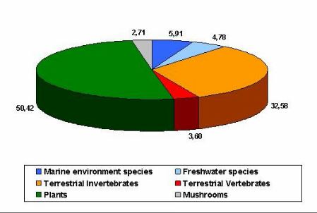 Specifically, 672
(576 terrestrial and 96 marine) vertebrate species are considered
under threat by the recent "IUCN Red List of Italian
Vertebrates"; in recent times, 6 of these threatened species
have become extinct in the region. The endangered species are 161 (of
which 138 are terrestrial and 23 are marine), equal to 28% of the
species assessed.
Specifically, 672
(576 terrestrial and 96 marine) vertebrate species are considered
under threat by the recent "IUCN Red List of Italian
Vertebrates"; in recent times, 6 of these threatened species
have become extinct in the region. The endangered species are 161 (of
which 138 are terrestrial and 23 are marine), equal to 28% of the
species assessed.
Regarding invertebrates, only 29%, are not threatened of extinction.
 In our region the problemes are related to
- high population densities
- introduction to alien species
-degradation of the terrain
4.5 Climate change
Currently,
the Italian territory is experiencing an increase in daily maximum
and minimum temperatures, connected to a shift of the entire
statistical distribution of values towards warmer temperatures and
thus an increase in average temperature.
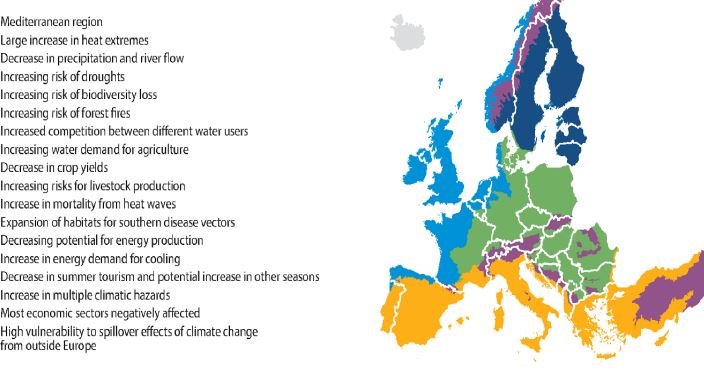
According to the models included in the Fourth Assessment Report, the Mediterranean hydrological cycle will be significantly influenced by global climate changes forecast for the XXI century. In fact, projections show a decrease in average annual precipitation in the Mediterranean area by about 20% (SRES A1B scenario, anomalies in the period 2070-2099 compared to 1950-2000)
A decrease in rainfall should be accompanied by an increase in evaporation in the Mediterranean region. With regard to the sea, this will mean an increase in surface water deficit. On land, most likely this will lead to a decrease in soil moisture, which will be particularly pronounced during the summer
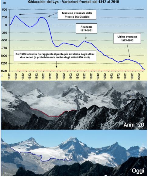
On the Italian Alps we are observing a rapid "disintegration of the glaciers," a veritable "collapse" of the cryosphere, which results in the extinction of the smaller glaciers, the fragmentation of the major glaciers (e.g. Brenva on the Mont Blanc, Lys on the Monte Rosa, East Fellaria on Bernina), the emergence of ever larger rock "windows", the formation of numerous ice-contact glacial lakes and the increase of surface debris cover leading to the transformation of the Italian Alps glaciers from the classical "white" glaciers into "blacks glaciers, whose area of ablation is completely covered with debris thicker than 1 meter.
5. Portugal
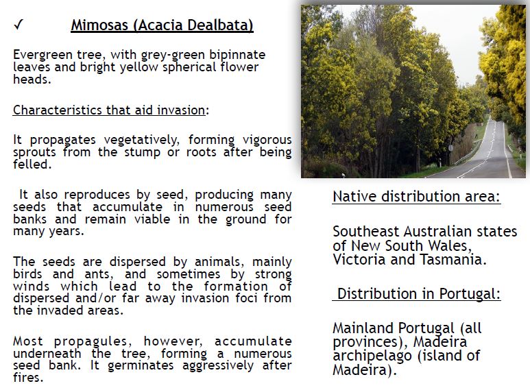
5.1 Invasive species
5.2 Fires
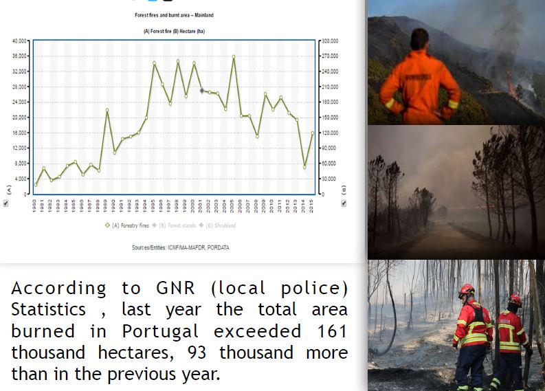
On 9 August 2016 a fire, allegedly by arson, started at the S. Roque parish in Madeira that quickly spread throughout the region of Southern Madeira and to its capital Funchal.
The fire was controlled: four casualties were recorded and a thousand of people displaced.
5.3 Floods and lanslides
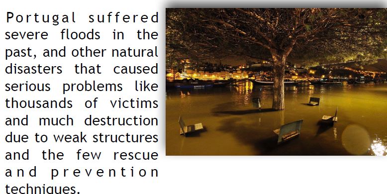
Lisbon is the Country that had more occurrences of floods and landslides in the last 150 years.
From 1865 until 2015, the capital has registered 56 landslides that caused 32 dead, 125 evacuated
and 402 homeless
5.4 Earthquakes and eruptions
Currently, the earthquakes in Portugal occur with great frequency but low magnitude. It islikely that, in the future, we may come to have an earthquake as severe as what occurred in the past.
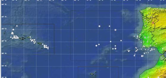
 In continental Portugal there are no cases of active volcanism besides thermal springs (secondary volcanism) that are pretty common. However, there are volcanic events in the Azores islands. That's because they’re volcanic islands and 9 of the volcanoes that formed them are still active.
Submarine eruptions are not rare and there are
p l e n t y o f c a s e s o f secondary volcanism on
the islands like fumaroles or thermal springs.
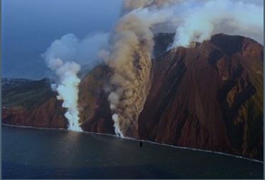
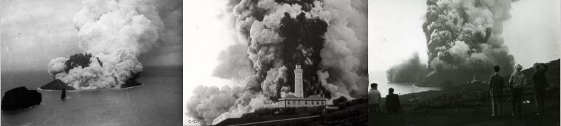
The Capelinhos eruption
This is the most intense volcanic eruption in Portugal. It occurred in Faial, one of the islands of the Azores archipelago on 27th September 1953. This eruption was of the explosive type characterizedby the big quantities of pyroclastic material (varying from rocks to dust) and gas released. Following a 2 day intense seismic period with more than 200 earthquakes, of an intensity not exceeding V of the Mercalli intensity scale.
There were a lot of buildings affected: broken windows, tiles falling from roofs. Cultivated fields were covered with a thick layer of ash.However, there were no victims. People were forced to migrate
significantly between 1957 and 1960.
6. Romania
Romania’s territory is exposed to a large number of natural risks as a result of its geographical position and landscape, such as:
-earthquakes
-floods
-landslides
-dangerous meteorological phenomena
- forest fires
- .
.
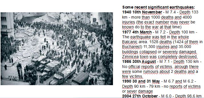
6.1 Earthquakes
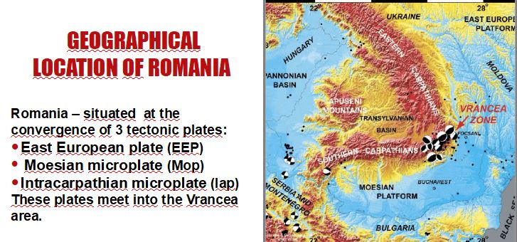
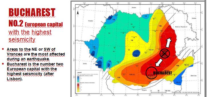
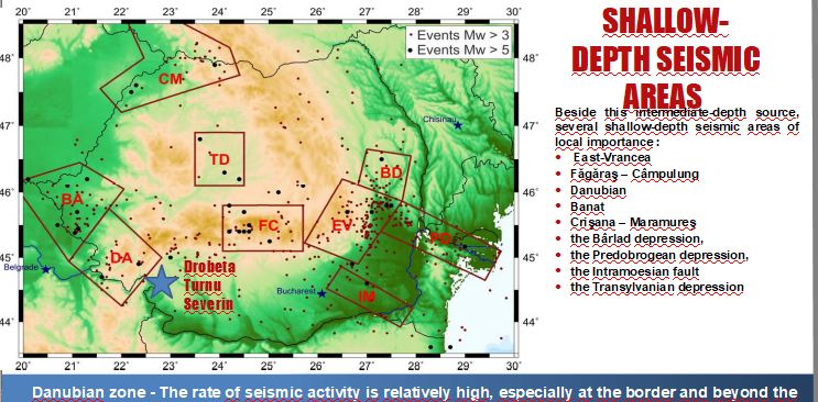
 Romania is situated in a seismic active region
Has a moderate seismic activity
Has a history of devastating and deadly earthquakes.
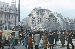
The Bucharest area has experienced a number of earthquakes of varying intensities, up to M 7,4 .
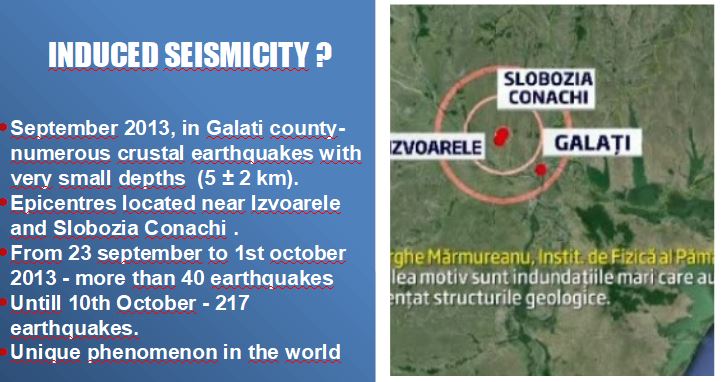
Initially, scientists have found that earthquakes were caused by heavy rains and flooding in the area. Based on preliminary investigations on the spot, seismologists from the National Institute for Earth Physics said the blame should be an oldest fault, a seismically sensitive area, which was reactivated.
The first conclusions of experts, based on data collected are that earthquakes can be natural (mechanical suffusion) or anthropogenic (extraction activity based on injection wells)
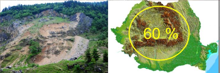
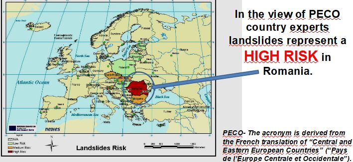
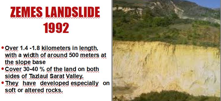
6.2 Landslides
It is a common hazard in Romania
Mostly it occur in the Carpathian Mountains and hilly regions, on more than 60% of the territory
Number of human victims of this natural hazard is very low.
Landslide causes substantial damage to human property in affected regions.
An increase in landslide frequency has been observed in recent years, related to extreme rainfall resulting from climate change.
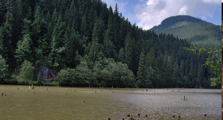 In our country the most important and popular landslide was the collapse of a slope due to an earthquake of 6.9 magnitude, which blocked the Bicaz River and formed the Red Lake.

6.3 Desertification
In Romania drought and desertification are:
-from natural causes
- from anthropogenic causes (deforestation, destruction of irrigation etc.)
In the last century - increase in the average annual temperature with 0.5 degrees C.
A more pronounced warming (0.8 degrees) was manifested in the S and SE, where the average annual temperature has reached 11 degrees, with more than 3 degrees higher than in the N.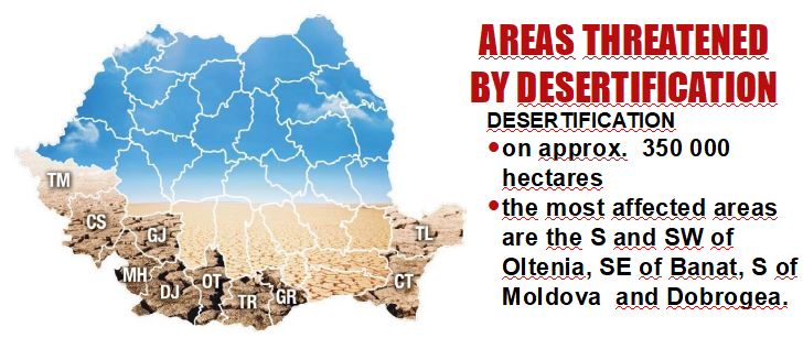
6.4 Floods
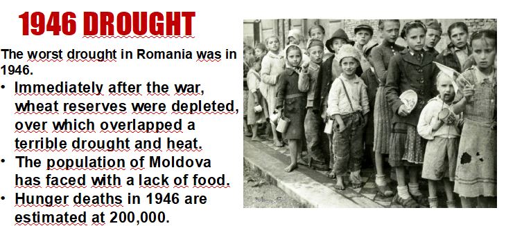
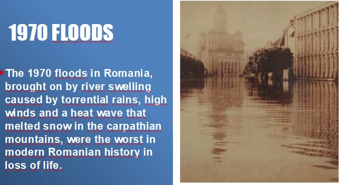
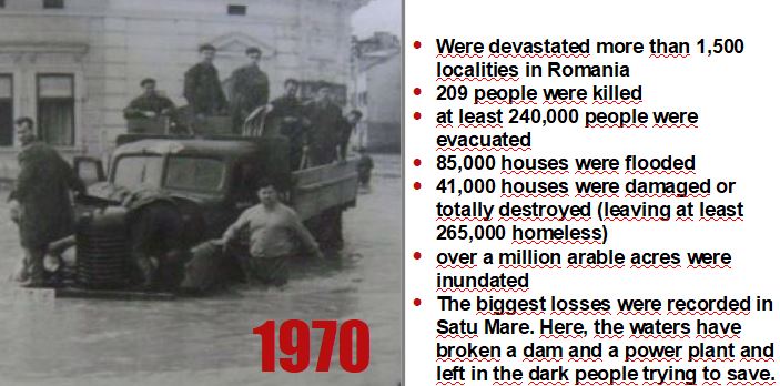
Romania is known as one of the most flood-prone countries in Europe. Floods killed 1,000 people in 1926; 215 people in 1970; 60 people in 1975; 108 people in 1991; and 33 people in 1995; 76 people in 2005; 21 in 2010.
The most frequent and severe disasters in Romania are floods
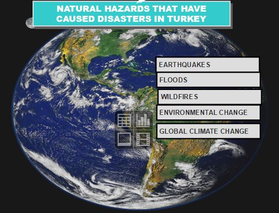
7. Turkey
Turkey is often faced with great natural disasters due to the negative nature of its land structure, ground form and meteorological conditions.
Thousands of lives and huge amounts of property are being lost as a result of these disasters.
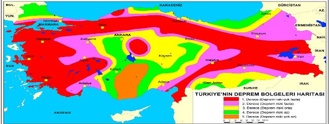
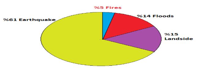 Taking the geological and geomorphological structure of our country into account, earthquakes are being in the first place.landslides are in the second,floods are the third and the fires are in the fifth place.
7.1 Earthquakes
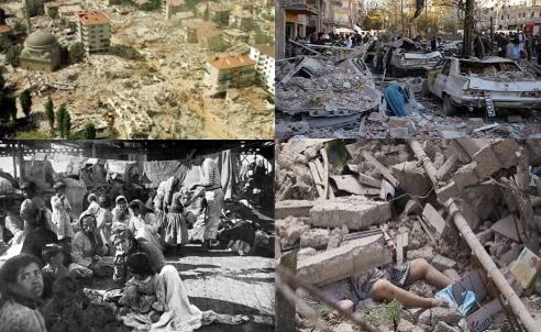 Number of people lost their lives in Turkey at natural disasters occured in the last 70 years is 100.000,
The Number of DAMAGED HOUSES ARE 600.000
1000 people on average die at earthquakes each year
A lot of people were ınjured….
A lot of people had to immigrate.
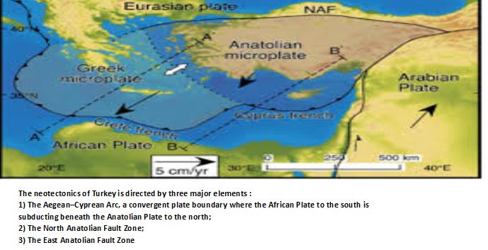
Turkey is located in one of the most actively deforming regions in the world
TECTONIC EARTHQUAKES
COLLAPSED EARTHAQUAKES
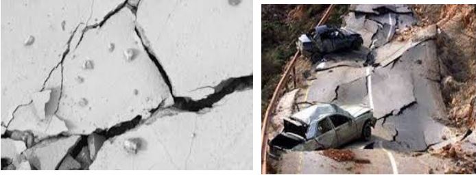
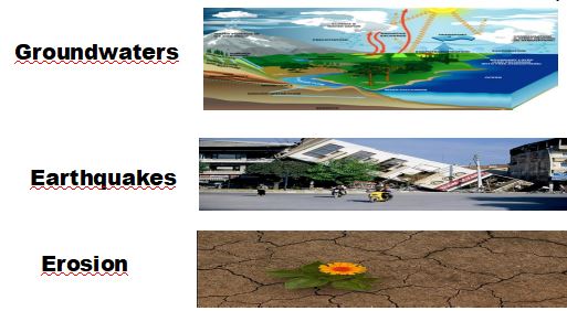
In easy-melting karstic areas such as rocksalt, gypsum and limestone, large voids form underground over time. Over these gaps, after a while, they collapse.
Collapse earthquakes are small earthquakes occuring in regions of underground caverns and mines
Collapse earthquakes are also produced by massive landsliding.
It is common in the Mediterranean
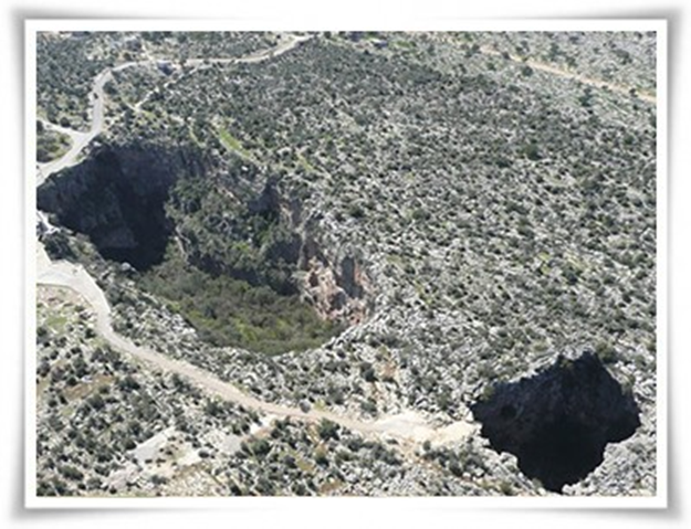 There are more than 40 caves in Turkey. Sometimes there are collapses and
arising from karstic structures from time to time around Antalya.
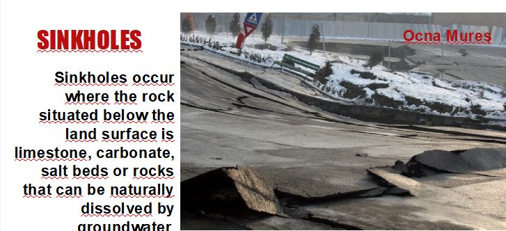
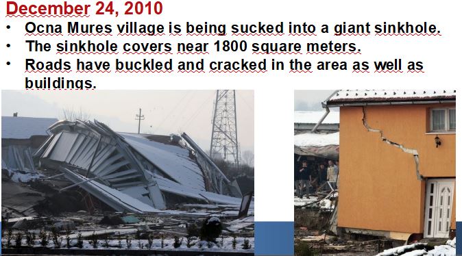
7.2 Sinkholes
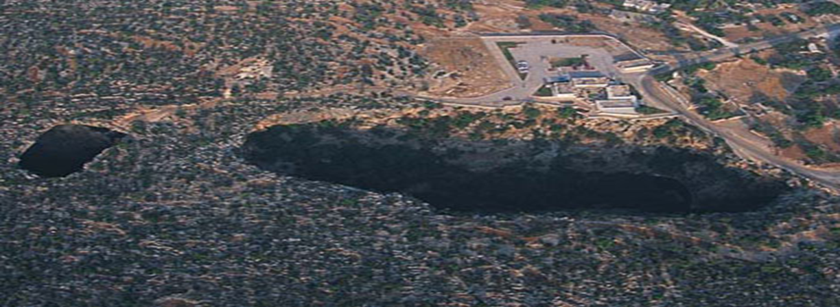 Water has been taken to the earth for 10 years by underground deep water and irrigation is being done.
The geological structure of the region is highly susceptible to excavation of groundwater.
In recent years, underground waters from global warming have been unable to feed and such gaps have arisen.
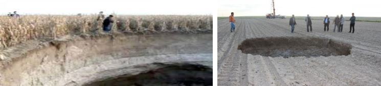
While the corn field in Karapınar District of Konya was being harvested, there was a sudden collapse of the ground crust at a depth of 70 meters and a depth of 80 meters. It's thought they're being caused by limestone dissolving underground.there are more than 200 only this area
7.3 Landslides
Landslides are caused by
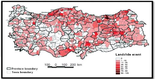 landslides are seen in three region
 |
|---|
Landslides ESPECIALLY occur in NORTH of Turkey. In a landslide, masses of rock, earth, or debris move down a slope.
Landslides may be small or large, slow or rapid.
7.4 Floods
Due to its complex topographic features
- its proximity to water
-being in a transition zone for different large scale weather circulations systems, variable climatic features appear to be dominant over the country
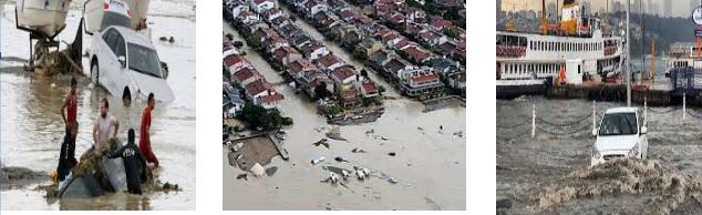
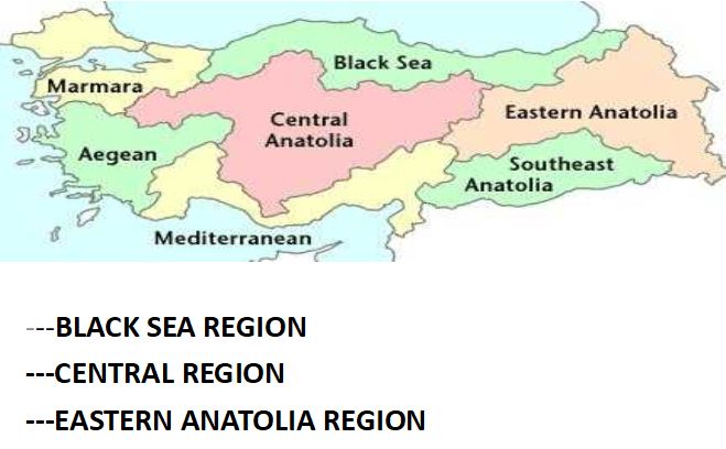
In our country most of the rivers and large flood plains in the Black Sea region in the valley lived on.
7.5 Fires
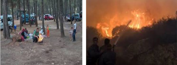 The majority of forest fires are caused by people.
Fires also destroy houses and almost anything in its way.
The city spends millions of money to fight them with chemicals, logistics, aircrafts and trucks, time and personnel.
The economic loss can be huge.
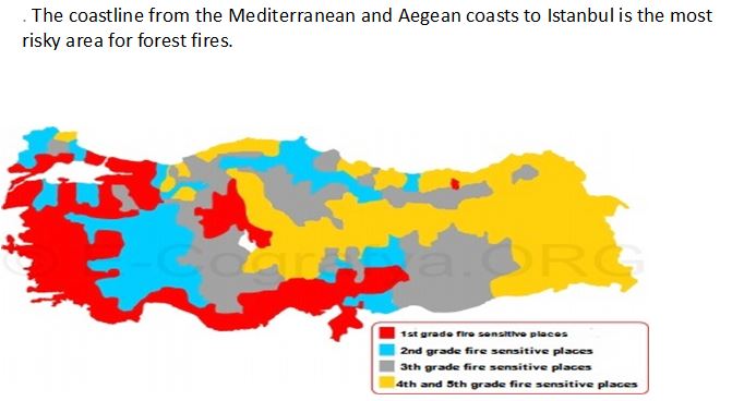
Besides, a lot of animals and plants species are in danger
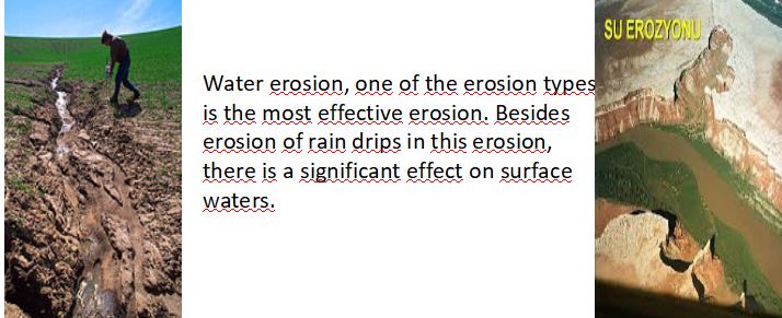
7.6 Erosion
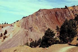 In Turkey, 90% is exposed to water erosion and 1% is exposed to wind erosion. In agricultural soils this ratio is about 75% for water erosion. As a result of erosion in Turkey, 500 million tons of fertile soil are lost annually
The formation of erosion takes place with natural factors,
but the fact that erosion causes irreparable damage occurs when people accelerate these factors.
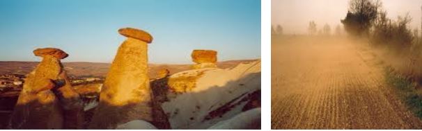 Wind erosion, another type of erosion, is the erosion and transport phenomenon caused by the wind. he erosion leads to the loss of fertile lands and leads to the formation of fairy chimneys, causing a natural beauty to come to fruition, creating tourism zones and creating a contradiction. Protected column erosion, which is a type of special erosion at the end of many years, causes these occurrences.
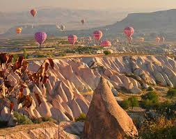
7.7 Drought
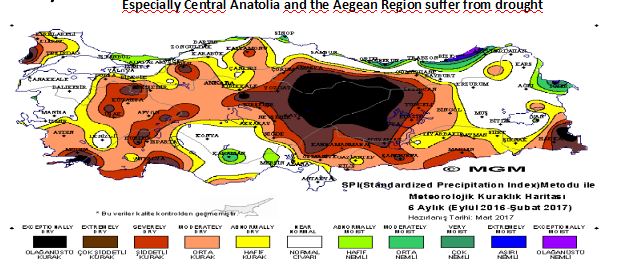
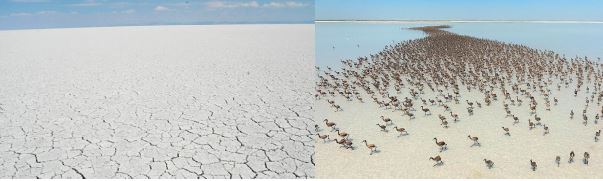 Lake Tuz is the second most saline lake in the world (32.9% salt), Due to decreasing rainfall and over use of water resources, almost half of the famous salt lake has dried out .
7.7 Avalances
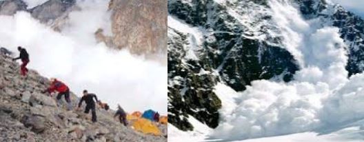 Turkey is a mountainous country.besides this there are different causes
_The structure of the land,
_the effect of the sun and
_ the direction of the blows of dominant winds blowing in the region during the period December –March
 The majority occur in the mountainous parts of the Eastern and Southeastern Anatolia regions and in some parts of the Black Sea Region
Avalanche events, which are seen almost every year in our country, lead to loss of life and property, closure of roads, damage of natural ecosystems, disconnection of energy and communication lines
7.8 Marine pollution
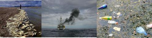
The sea which is polluted by reasons such as flood waters reaching the sea with waste streams ,sewage water and unawareness of the people constitute a serious threat in term of both human health and the extinction of animal species.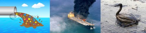
7.9 Air pollution
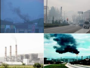 Sulfurdioxide, nitrogenoxide and carbondioxide
Smog, one of the severe issues